India-Bhutan-Myanmar Wildlife Corridors: Tigers, Elephants & TraMCA Explained

Assam sits inside the only Indian landscape with a formally governed international wildlife-conservation programme — the Transboundary Manas Conservation Area, shared with Bhutan. Nearly 3,000 kilometres to the east, a second, much less formalised connection links Arunachal Pradesh's Namdapha National Park with Myanmar's Hkakabo Razi. This article sets out exactly what each of these landscapes is, how they differ in legal status, what Assam-specific corridors matter most, and what the current elephant-corridor and border-security picture looks like in 2026. It also covers the material most useful for APSC, ADRE and UPSC preparation, including a revision list, original MCQs and a source-checked FAQ.
Quick Answer
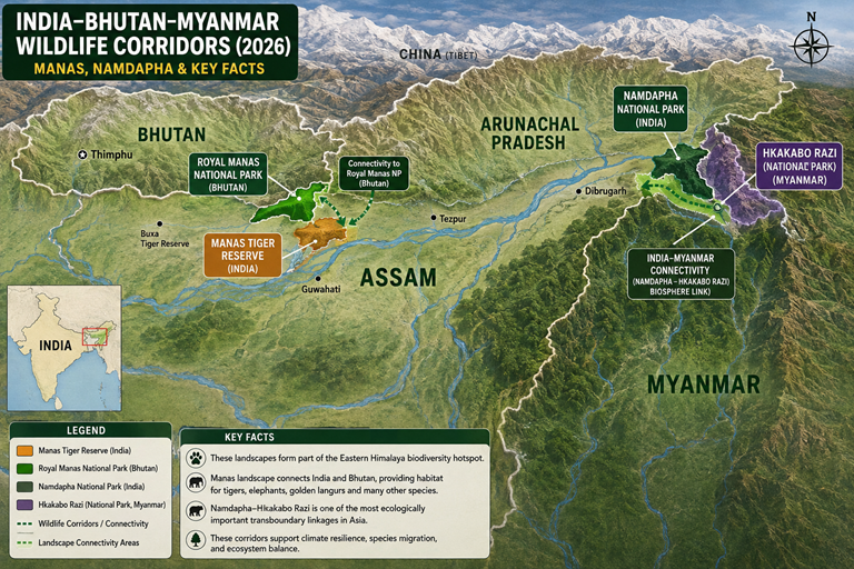
India's most functional transboundary wildlife landscape is the Transboundary Manas Conservation Area (TraMCA), a jointly governed programme created in 2011 that links Assam's Manas Tiger Reserve with Bhutan's Royal Manas National Park across more than 6,500 sq km. Further east, Namdapha National Park in Arunachal Pradesh lies directly adjacent to Myanmar's Hkakabo Razi National Park, forming a contiguous, biologically important forest block — but this is a proposed ecological connection studied by researchers, not a jointly administered treaty like TraMCA. Within Assam, the strongest documented corridors link Kaziranga to the Karbi Anglong hills, and a newer chain of protected areas — Manas, Sikhna Jwhwlao and Raimona — now runs almost continuously to the Bhutan border.
At a Glance
| Landscape / Area | Countries | Indian State/Region | Key Protected Areas | Important Species | Conservation Status / Significance |
|---|---|---|---|---|---|
| Manas–Royal Manas / TraMCA | India, Bhutan | Assam (BTR) | Manas Tiger Reserve, Royal Manas NP, Phibsoo WS, Jomotsangkha WS | Tiger, Asian elephant, greater one-horned rhino, pygmy hog, golden langur | Formal transboundary conservation programme, est. 2011; core is a UNESCO Natural World Heritage Site |
| Namdapha–Hkakabo Razi | India, Myanmar | Arunachal Pradesh | Namdapha NP & TR, Hkakabo Razi NP, Hponkan Razi WS | Namdapha flying squirrel, clouded leopard, red panda, tiger | Contiguous forest landscape; proposed biological corridor, no bilateral treaty |
| Manas–Sikhna Jwhwlao–Raimona | India, Bhutan | Assam (BTR) | Manas TR, Sikhna Jwhwlao NP, Raimona NP, Phibsoo WS (Bhutan) | Golden langur, Asian elephant, tiger, gaur | Contiguous chain of Indian protected areas feeding into the TraMCA landscape |
| Kaziranga–Karbi Anglong | India (intrastate) | Assam | Kaziranga NP & TR, Karbi Anglong forests | One-horned rhino, tiger, elephant, wild water buffalo | Nine ground-documented animal-movement tracts; elevated highway corridor under construction |
What Is a Wildlife Corridor?
A wildlife corridor is a strip or patch of habitat that connects two otherwise separated areas of suitable habitat, allowing animals to move between them. Corridors matter for several linked biological reasons:
- Movement and dispersal — young or displaced animals need routes to reach new territory.
- Seasonal movement — species such as elephants and, in flood-prone Assam, even rhinos and tigers, shift ground with the seasons.
- Breeding and gene flow — connected populations can interbreed, which maintains genetic diversity.
- Recolonisation — a corridor lets a species return to habitat it had disappeared from, once conditions improve.
Wildlife Corridor vs Conservation Landscape
| Term | Meaning |
|---|---|
| Wildlife corridor | A specific, mappable strip of habitat connecting two patches, used for regular animal movement. |
| Ecological / biological connectivity | A broader, less formally defined ecological link between habitats, which may or may not include a named corridor. |
| Conservation landscape | A large area encompassing multiple protected areas, corridors and buffer forests, managed with a shared conservation goal. |
| Transboundary conservation area | A landscape crossing an international boundary where two or more governments have agreed to cooperate on management. |
This distinction is genuinely tested in APSC and UPSC papers, because official Indian documents use these terms precisely rather than interchangeably.
India-Bhutan Wildlife Connectivity: The Manas Landscape
Manas Tiger Reserve
Manas is located in the Himalayan foothills of western Assam, spanning the districts of Chirang, Baksa, Bongaigaon, Barpeta, Kokrajhar and Darrang. It carries six national and international designations simultaneously: National Park (1990), Tiger Reserve (1973), Biosphere Reserve (1989), Elephant Reserve (as part of the former Chirang-Ripu Elephant Reserve, notified 2003), Important Bird Area, and UNESCO Natural World Heritage Site (inscribed 1985). The reserve's core Wildlife Sanctuary covers roughly 39,100 hectares, while the full Tiger Reserve extends to about 2,837 sq km. Manas was placed on UNESCO's List of World Heritage in Danger in 1992 after insurgency-related damage to infrastructure and wildlife populations, and was removed from that list in 2011 following sustained recovery efforts.
Royal Manas National Park
Royal Manas is Bhutan's oldest protected area, lying immediately across the border, north of the Indian reserve. The Manas River, which rises in Bhutan and flows into the Brahmaputra, links the two parks physically as well as ecologically — readers can see how this fits the wider river network in the Brahmaputra River System explained.
What Is TraMCA?
The Transboundary Manas Conservation Area (TraMCA) is a formal joint conservation programme, created in 2011 through a Letter of Agreement between Bhutan's Department of Forests and Park Services and the Bodoland Territorial Council of Assam. It covers an area of more than 6,500 sq km, running from the Sankosh river in the west (the boundary of Ripu Reserve Forest in India) to Bhutan's Jomotsangkha Wildlife Sanctuary in the east, and from the southern boundary of Manas Tiger Reserve to the northern edge of Royal Manas National Park. On the Indian side it draws in the Ripu-Chirang Reserved Forest, Manas National Park and Khalingduar Reserved Forest; on the Bhutanese side it includes Phibsoo Wildlife Sanctuary, Royal Manas National Park, Jomotsangkha Wildlife Sanctuary and a network of designated biological corridors. This is TraMCA's key distinguishing feature compared with the India-Myanmar landscape: it is a named, bilaterally agreed programme with a defined governance structure, not merely an ecological observation.
Wildlife and Biodiversity
The combined TraMCA landscape supports more than 1,500 species of mammals, birds and vascular plants. Key large mammals include the tiger, Asian elephant, greater one-horned rhinoceros, wild water buffalo, pygmy hog, hispid hare, clouded leopard and golden langur — the last of which occurs naturally only in a narrow belt between the Manas and Sankosh rivers in Assam and south-central Bhutan.
How Transboundary Conservation Works
TraMCA functions through joint camera-trap monitoring, coordinated anti-poaching patrols, and information-sharing between Bhutanese and Indian park authorities, supported by IUCN and WWF. Camera-trap-based tiger surveys are conducted on both sides of the border; India's Manas tiger count rose from 9 in 2010 to 25 in 2018, while Bhutan's Royal Manas count rose from 12 in 2008 to 26 in 2018, according to figures cited by IUCN. Conservation NGOs including Aaranyak and WWF-India work alongside the two governments within this framework.
Manas — Important Facts
| Designation | Year / Detail |
|---|---|
| Wildlife Sanctuary declared | 1928 (game sanctuary origin), formalised 1950 |
| Project Tiger Reserve | 1973 |
| UNESCO World Heritage Site | Inscribed 1985; on Danger list 1992–2011 |
| Biosphere Reserve | 1989 |
| National Park status | 1990 |
| Elephant Reserve (Chirang-Ripu) | 2003; renamed Sikhna Jwhwlao National Park in 2025 |
| TraMCA established | 2011 |
India-Myanmar Wildlife Connectivity: Namdapha and Hkakabo Razi
Namdapha National Park
Namdapha National Park and Tiger Reserve lies in the Changlang district of Arunachal Pradesh, in the far eastern corner of India where the Eastern Himalaya, Indo-Burma and South-West China biodiversity hotspots converge. It is one of the largest protected areas in India by area and hosts an unusually wide elevational range of habitat, from lowland tropical forest to high-altitude alpine zones.
Hkakabo Razi
Across the border in Myanmar's Kachin State lies Hkakabo Razi National Park, established in 1998 and covering 3,810 sq km — the largest national park in Myanmar and an ASEAN Heritage Park. It sits at the base of Mount Hkakabo Razi (5,882 m), Southeast Asia's highest peak. The adjoining Hponkan Razi Wildlife Sanctuary, gazetted in 2003, covers roughly 2,700 sq km. To the west, this landscape is contiguous with Namdapha in India; to the east, it borders China's Gaoligongshan Nature Reserve, part of the Three Parallel Rivers of Yunnan World Heritage Site.
Is Namdapha-Hkakabo Razi a Formal Wildlife Corridor?
This is where accuracy matters most. Unlike TraMCA, there is no bilaterally agreed, jointly administered treaty governing the India-Myanmar forest link. What exists is:
- A documented ecological continuum — the forests of Namdapha and Hkakabo Razi are physically contiguous, and UNESCO's tentative-list documentation for Hkakabo Razi explicitly notes this contiguity with Namdapha to the west.
- A proposed biological corridor — a joint geospatial study by the Wildlife Institute of India, ICIMOD and G. B. Pant Institute of Himalayan Environment and Development identified and mapped a proposed biological corridor between Namdapha National Park and Hkakabo Razi National Park, as part of trans-boundary landscape planning work.
- No formal governance mechanism comparable to TraMCA's Letter of Agreement or Bodoland Territorial Council-Bhutan cooperation structure.
In short: the connection is real and ecologically significant, but it should be described as a contiguous landscape with a proposed corridor, not as an established transboundary conservation programme.
Important Wildlife Corridors and Connectivity Landscapes of Assam
Kaziranga–Karbi Anglong
This is Assam's most rigorously documented wildlife corridor complex, part of the wider network covered in this guide to Assam's national parks and wildlife sanctuaries. Kaziranga National Park sits on the Brahmaputra floodplain; when the river floods each monsoon, rhinos, tigers, elephants and other wildlife move south to the higher ground of the Karbi Anglong hills. A government-appointed committee formally delineated nine animal corridor tracts — including the Panbari, Haldhibari, Amguri and Kanchanjuri corridors — running across the NH-715 (formerly NH-37) stretch between the park and the hills. A long-term camera-trap study covering these corridors recorded 39 species over nearly 11,000 trap nights, including nine individual tigers and six leopards, with elephants using the corridors most frequently. These corridors face heavy pressure from tea estates, quarrying, sand mining and unregulated construction, and conservationists have flagged repeated encroachment in the Haldhibari and Panbari tracts.
2026 update: In January 2026, India's National Board for Wildlife approved a ₹6,950-crore project that includes a 34.5-km elevated wildlife corridor along NH-715 through Kaziranga, designed to let animals move freely beneath the highway rather than at grade. The approval carries 34 conditions, including a recommendation that the adjoining Karbi Anglong Wildlife Sanctuary be declared a satellite core of the tiger reserve, and requires long-term corridor-use monitoring by the Assam Forest Department and the Wildlife Institute of India once construction is complete.
Orang and the Brahmaputra Riverine Belt
Orang National Park, on the northern bank of the Brahmaputra, is described in forest-department and conservation literature as anchoring a roughly 180-km riverine connectivity belt running along the Brahmaputra floodplain between Orang and Kaziranga, used by tigers, rhinos and elephants. This connection is less intensively studied through ground-validated, GPS-collar or camera-trap data than the Kaziranga-Karbi Anglong corridors, and should be read as a broader floodplain connectivity landscape rather than a single mapped corridor.
Manas–Sikhna Jwhwlao–Raimona–Bhutan
This is the newest and, for Assam readers, one of the most important developments in the state's protected-area network. Three national parks now form a nearly continuous chain along the Bhutan border in the Bodoland Territorial Region:
- Manas National Park (notified 1990) — the anchor of the TraMCA landscape.
- Sikhna Jwhwlao National Park — notified on 5 March 2025 (Assam Cabinet approval 16 February 2025), covering 316.29 sq km across Chirang and Kokrajhar districts. It was upgraded from the former Chirang-Ripu Elephant Reserve (2003) and lies between Manas and Raimona, forming part of the Manas Biosphere Reserve landscape.
- Raimona National Park — declared on 9 June 2021, covering about 422 sq km in Kokrajhar district. It completes the western flank of the Manas landscape and connects toward Bhutan's Phibsoo Wildlife Sanctuary.
Together, these three parks — plus the adjoining Ripu and Chirang reserved forests — support one of India's most important elephant populations, seasonal tiger and gaur movement, and the core Indian range of the endangered golden langur. This makes Assam's own western protected-area network functionally continuous with the TraMCA landscape rather than a separate system.
Other Verified Connectivity Points
The National Tiger Conservation Authority has noted "stepping-stone" linkages between Gorumara, Jaldapara, Buxa and Ripu-Chirang forests spanning West Bengal and Assam, though connectivity further east toward the Sonai-Rupai-Nameri landscape has degraded over time, limiting the range over which wildlife can move even within Indian territory.
Elephant Corridors in India: Key Facts
India's Project Elephant Division, under the Ministry of Environment, Forest and Climate Change, published "Elephant Corridors of India 2023" after nearly two years of state-by-state ground validation carried out with technical support from the Wildlife Institute of India.
APSC/UPSC Fact Box
150 elephant corridors were ground-validated across 15 states in the 2023 report, up from 88 corridors identified in the 2005 "Gajah" report and 101 in the 2017 Wildlife Trust of India assessment. Of these, 48 corridors (32%) lie in the Northeast region, 52 (35%) in East-Central India, 32 (21%) in the South, and 18 (12%) in the North. West Bengal has the highest state total, with 26 corridors.
Of the 150 corridors, 126 (about 84%) fall entirely within a single state, while 19 cross state boundaries. The report also documents transnational elephant movement — six corridors linking India with Nepal, mostly in Uttar Pradesh, including the well-known Katerniaghat-Bardia link. Fifteen corridors were assessed as impaired and in need of restoration.
Why Wildlife Corridors Matter for Tigers
Tigers require large, often overlapping territories, and dispersing sub-adults need safe routes to find unoccupied habitat and mates outside their natal range. Isolated tiger populations lose genetic diversity over generations and become more vulnerable to local extinction from disease or poaching. Corridors allow source populations, such as those in Kaziranga or Manas, to support the recolonisation of degraded or vacant habitat elsewhere in the landscape — a strategy the National Tiger Conservation Authority treats as central to landscape-level tiger conservation, rather than protecting reserves as isolated islands.
Why Corridors Matter for Elephants
Asian elephants have some of the largest home ranges of any Indian mammal and undertake seasonal movements in search of food, water and mates that can span hundreds of kilometres and multiple states. When these historic routes are blocked by highways, railway lines, plantations or new settlements, elephants are forced into unfamiliar or unsuitable terrain, which is a major driver of human-elephant conflict, crop damage, and elephant deaths from train collisions and electrocution. This is precisely why the 2023 national corridor report frames corridor protection as central to reducing conflict, not only to conservation in the abstract.
Why Wildlife Corridors Matter for Genetic Diversity
The underlying logic is simple: connected populations allow gene flow, gene flow supports genetic diversity, and greater genetic diversity generally makes a population more resilient to disease and environmental change. This benefit should not be overstated — corridors alone cannot substitute for adequate habitat area or population size, but they are one of the few practical tools available for maintaining connectivity between habitat patches that development has already fragmented.
Major Threats to Wildlife Corridors
| Threat | Potential Impact |
|---|---|
| Roads and highways | Habitat fragmentation, vehicle-wildlife collisions |
| Railways | Movement barriers, train-strike mortality (notably for elephants) |
| Border infrastructure | Potential restriction of cross-border movement, depending on alignment |
| Mining and quarrying | Direct habitat loss and disturbance |
| Agricultural expansion and tea estates | Land-use change, loss of forest cover in corridor tracts |
| Urbanisation | Permanent fragmentation of habitat |
| Dams and hydropower | Landscape and hydrological alteration |
| Human-wildlife conflict | Retaliatory killing, displacement of animals from corridors |
| Climate change | Shifting habitat suitability, altered seasonal movement patterns |
Any specific ecological impact attributed to a named project should be treated as provisional unless supported by an environmental impact assessment or peer-reviewed study; this article does not attribute any confirmed ecological harm to a specific, ongoing infrastructure project.
India-Myanmar Border Infrastructure and Wildlife Connectivity
Border security policy along the India-Myanmar frontier has changed substantially since 2024, and this section reflects the position as of mid-2026.
In February 2024, the Union Home Minister announced that the government intended to scrap the Free Movement Regime (FMR), the arrangement that had allowed border residents to travel visa-free up to 16 km into each other's territory. In September 2024, the Cabinet Committee on Security gave in-principle approval for a roughly ₹31,000-crore, 10-year plan to fence the border and build patrol roads. Rather than an immediate blanket withdrawal, the Ministry of Home Affairs introduced a biometric, QR-coded border-pass system from December 2024, initially covering a 10-km zone along the Manipur-Myanmar border. Physical fencing has proceeded slowly and unevenly: independent assessments in 2025 put completed fencing at around 30 km of the 1,643-km border (under 2%), concentrated mainly near Moreh in Manipur. In the densely forested, mountainous stretches of Arunachal Pradesh and Manipur, planners have piloted a Hybrid Surveillance System combining sensors and night-vision technology in place of conventional fencing, and survey work continues in Arunachal Pradesh and Mizoram. Mizoram and Nagaland's state assemblies have passed resolutions opposing both the fencing and the withdrawal of the FMR, citing shared ethnic ties across the border.
For wildlife connectivity, this evolving picture carries genuine but as-yet uncertain implications. Any continuous physical fencing through forested terrain could fragment the seasonal movement routes that species use to cross the frontier, though the ultimate impact depends heavily on final alignment, the extent of wildlife-sensitive design, and how much of the border ends up under conventional fencing versus sensor-based surveillance. As of mid-2026, no wildlife-specific mitigation plan for the India-Myanmar border fence has been publicly confirmed by the Ministry of Environment, Forest and Climate Change.
Wildlife Corridors and Local Communities
Corridor conservation in Assam and the wider Northeast is inseparable from the people living in and around these landscapes. Elephant crop damage is one of the most immediate and costly forms of human-wildlife conflict along corridors such as Kaziranga-Karbi Anglong and the Manas-Raimona belt, and compensation schemes, early-warning systems and community-based patrolling are central to sustaining local support for conservation. Village-level volunteer initiatives assist Assam Forest Department staff with patrolling in Manas's buffer zones, and the Bodoland Territorial Council's role in governing Manas, Raimona and Sikhna Jwhwlao reflects a broader post-2020 shift toward community and BTR-led stewardship of these landscapes. These same floodplain and buffer habitats overlap substantially with Assam's wetlands and Ramsar sites, which serve a similar dual role of ecological value and community livelihood. Eco-tourism around Kaziranga, Manas and Raimona also increasingly functions as a direct economic incentive for local communities to support corridor protection rather than encroachment.
Laws and Government Initiatives Supporting Wildlife Connectivity
Corridor protection in India rests on a mix of dedicated wildlife law and species-specific government programmes, along with judicial oversight such as the National Green Tribunal's role in Assam's environmental cases:
- Wildlife (Protection) Act, 1972 — the base legal framework for protected areas, sanctuaries and Schedule I species that corridors are designed to safeguard.
- Project Tiger — supports landscape-level tiger conservation, including corridor and buffer management around reserves such as Manas and Kaziranga.
- Project Elephant — the nodal programme responsible for the 2023 national corridor validation exercise and for elephant reserve management, including the former Chirang-Ripu (now Sikhna Jwhwlao) landscape.
- NTCA corridor guidance — the National Tiger Conservation Authority issues landscape-level notes identifying stepping-stone and degraded linkages, such as those noted for the Manas-Sonai-Rupai-Nameri stretch.
- Eco-Sensitive Zones — buffer notifications around protected areas such as Kaziranga are directly relevant to corridor integrity, since ESZ boundaries determine how much surrounding land is regulated against mining, quarrying and construction.
2026 Updates / Current Status
This article reflects the verified position as of August 2026. The clearest recent developments are: the National Board for Wildlife's January 2026 approval of the Kaziranga elevated wildlife corridor project on NH-715; the continued, uneven progress of India-Myanmar border fencing and the replacement of the Free Movement Regime with a biometric pass system; and the consolidation of Assam's western protected-area network following the 2025 notification of Sikhna Jwhwlao National Park alongside Manas and Raimona. No new bilateral treaty covering the Namdapha-Hkakabo Razi landscape has been confirmed as of this update.
APSC, ADRE & UPSC Quick Revision
Pair this list with the current affairs for APSC and ADRE section for related updates while revising.
- TraMCA stands for the Transboundary Manas Conservation Area, established in 2011.
- TraMCA links India's Manas Tiger Reserve (Assam) with Bhutan's Royal Manas National Park.
- TraMCA covers an area of more than 6,500 sq km.
- TraMCA was formalised through a Letter of Agreement between Bhutan's Department of Forests and Park Services and the Bodoland Territorial Council.
- Manas was inscribed as a UNESCO Natural World Heritage Site in 1985; it was on the Danger list from 1992 to 2011.
- Namdapha National Park is in Changlang district, Arunachal Pradesh.
- Hkakabo Razi National Park, established 1998, is Myanmar's largest national park (3,810 sq km).
- The Namdapha-Hkakabo Razi link is a contiguous landscape with a proposed biological corridor, not a formal bilateral treaty.
- India's 2023 elephant corridor report identified 150 corridors across 15 states, up from 88 in 2005 and 101 in 2017.
- The Northeast region holds 48 (32%) of India's elephant corridors; West Bengal has the most of any single state (26).
- Raimona National Park (2021) and Sikhna Jwhwlao National Park (2025) are Assam's newest national parks, both in the Bodoland Territorial Region.
- India shares a 699-km border with Bhutan (Sikkim, West Bengal, Assam, Arunachal Pradesh) and a 1,643-km border with Myanmar (Arunachal Pradesh, Nagaland, Manipur, Mizoram).
- The Free Movement Regime with Myanmar was announced for withdrawal in February 2024 and replaced by a biometric border-pass system from December 2024.
- Golden langur's core Indian range lies between the Manas and Sankosh rivers.
- Kaziranga-Karbi Anglong connectivity comprises nine documented animal corridor tracts, including Panbari, Haldhibari, Amguri and Kanchanjuri.
Practice MCQs
Q1. The Transboundary Manas Conservation Area (TraMCA) represents formal cooperation between:
A. India and Nepal B. India and Bhutan C. India and Myanmar D. Bhutan and Myanmar
Answer: B
Explanation: TraMCA, established in 2011, links Assam's Manas Tiger Reserve with Bhutan's Royal Manas National Park through a bilateral agreement.
Q2. Which of the following best describes the Namdapha-Hkakabo Razi landscape as of 2026?
A. A formally administered transboundary treaty like TraMCA B. A contiguous forest landscape with a proposed but not formally established corridor C. An area with no ecological connection at all D. A UNESCO-managed joint national park
Answer: B
Explanation: Researchers and UNESCO documentation describe the landscape as contiguous, and a biological corridor has been proposed, but no bilateral governance mechanism exists.
Q3. Royal Manas National Park is located in which country?
A. Nepal B. Myanmar C. Bhutan D. China
Answer: C
Explanation: Royal Manas is Bhutan's oldest protected area, situated directly across the border from Assam's Manas Tiger Reserve.
Q4. As per the "Elephant Corridors of India 2023" report, how many elephant corridors were ground-validated nationally?
A. 88 B. 101 C. 150 D. 200
Answer: C
Explanation: The 2023 Project Elephant/WII report ground-validated 150 corridors across 15 states, up from 88 in 2005 and 101 in 2017.
Q5. Which Indian region holds the second-highest share of elephant corridors after East-Central India?
A. Northern India B. Southern India C. Northeast India D. Western India
Answer: C
Explanation: The Northeast holds 48 corridors (32%), behind East-Central India's 52 (35%).
Q6. Manas National Park was removed from UNESCO's List of World Heritage in Danger in which year?
A. 1992 B. 2003 C. 2011 D. 2021
Answer: C
Explanation: Manas was placed on the Danger list in 1992 due to insurgency-related damage and removed in 2011 after sustained recovery.
Q7. Sikhna Jwhwlao National Park, notified in 2025, was previously known as:
A. Orang Wildlife Sanctuary B. Chirang-Ripu Elephant Reserve C. Nameri Reserve Forest D. Barnadi Wildlife Sanctuary
Answer: B
Explanation: The Chirang-Ripu Elephant Reserve, notified in 2003, was upgraded and renamed Sikhna Jwhwlao National Park in March 2025.
Q8. Which river physically links Manas National Park (India) and Royal Manas National Park (Bhutan)?
A. Sankosh B. Manas C. Subansiri D. Dibang
Answer: B
Explanation: The Manas River flows from Bhutan through both protected areas before joining the Brahmaputra.
Q9. The golden langur's core natural range in India lies between which two rivers?
A. Brahmaputra and Subansiri B. Manas and Sankosh C. Kameng and Manas D. Dibang and Lohit
Answer: B
Explanation: The golden langur occurs naturally only in a narrow belt between the Manas and Sankosh rivers, spanning Assam and south-central Bhutan.
Q10. What is the primary conservation purpose of the elevated wildlife corridor approved for Kaziranga in January 2026?
A. To create a new tourist attraction B. To allow uninterrupted wildlife movement beneath the NH-715 highway C. To replace Kaziranga's existing boundary fence D. To build a new railway line
Answer: B
Explanation: The National Board for Wildlife approved a 34.5-km elevated stretch on NH-715 so that animals, especially during monsoon floods, can move beneath the road rather than crossing it at grade.
Q11. Which of the following is NOT one of the nine documented Kaziranga-Karbi Anglong corridor tracts?
A. Panbari B. Haldhibari C. Kanchanjuri D. Sankosh
Answer: D
Explanation: Sankosh is a river forming part of the TraMCA western boundary, not a Kaziranga-Karbi Anglong corridor tract.
Q12. The Free Movement Regime along the India-Myanmar border was announced for withdrawal in:
A. February 2024 B. December 2024 C. March 2025 D. June 2021
Answer: A
Explanation: The Union Home Minister announced the intended withdrawal of the FMR in February 2024; a biometric pass system replaced it in parts of the border from December 2024.
Q13. Hkakabo Razi National Park, Myanmar's largest national park, is located in which state?
A. Shan State B. Kachin State C. Rakhine State D. Sagaing Region
Answer: B
Explanation: Hkakabo Razi National Park lies in the northernmost part of Kachin State, bordering Arunachal Pradesh.
Q14. Which body provided technical support for the "Elephant Corridors of India 2023" report?
A. National Tiger Conservation Authority B. Wildlife Institute of India C. Botanical Survey of India D. Zoological Survey of India
Answer: B
Explanation: The report was prepared by Project Elephant, MoEFCC, with technical support from the Wildlife Institute of India.
Q15. Raimona National Park primarily strengthens wildlife connectivity toward which Bhutanese protected area?
A. Jigme Dorji National Park B. Phibsoo Wildlife Sanctuary C. Royal Manas National Park D. Thrumshingla National Park
Answer: B
Explanation: Raimona completes the western flank of the Manas landscape and connects toward Bhutan's Phibsoo Wildlife Sanctuary.
Readers looking to build further exam speed can practice more environment and geography MCQs in the main question bank.
Key Takeaways
- TraMCA (2011) is India's only formally governed transboundary wildlife conservation programme, linking Manas Tiger Reserve with Royal Manas National Park across more than 6,500 sq km.
- The Namdapha-Hkakabo Razi landscape is ecologically contiguous with a proposed biological corridor, but it has no formal bilateral treaty — a distinction that matters for accurate exam answers.
- Assam's western protected-area network — Manas, Sikhna Jwhwlao (2025) and Raimona (2021) — now forms a near-continuous chain toward the Bhutan border.
- Kaziranga-Karbi Anglong is Assam's most rigorously documented intrastate corridor complex, with nine identified animal-movement tracts and a new elevated highway corridor approved in January 2026.
- India's 2023 national report ground-validated 150 elephant corridors across 15 states, with the Northeast accounting for 48 of them.
- The India-Myanmar border is undergoing major security changes since 2024 — the Free Movement Regime's withdrawal and slow, uneven fencing progress — with uncertain but potentially significant implications for cross-border wildlife movement.
- Corridors matter for tigers and elephants primarily through genetic exchange, dispersal, and reducing isolation of small populations.
- Roads, railways, mining, agriculture and border infrastructure are the most consistently documented threats to corridor integrity in this region.
For timed practice on this and related topics, aspirants can attempt free daily mock tests.
Frequently Asked Questions
What are the major wildlife corridors between India and Bhutan?
The core connection is the Transboundary Manas Conservation Area (TraMCA), linking Manas Tiger Reserve in Assam with Royal Manas National Park in Bhutan, supported by adjoining Assam parks including Sikhna Jwhwlao and Raimona.
Which wildlife corridor connects Manas and Royal Manas?
There is no single named "corridor" strip; rather, the two parks form the core of the broader TraMCA landscape, connected through contiguous forest and designated biological corridors within the 6,500-sq-km TraMCA area.
What is TraMCA?
TraMCA is the Transboundary Manas Conservation Area, a formal India-Bhutan conservation programme established in 2011 to jointly manage the Manas landscape.
Is there a wildlife corridor between India and Myanmar?
There is a documented contiguous forest landscape and a proposed biological corridor between Namdapha National Park (India) and Hkakabo Razi National Park (Myanmar), but no formal bilateral treaty exists as of 2026.
What is the Namdapha-Hkakabo Razi landscape?
It is a transboundary forest complex at the junction of the Eastern Himalaya, Indo-Burma and South-West China biodiversity hotspots, recognised by researchers and UNESCO documentation as ecologically contiguous.
Which wildlife corridors are important in Assam?
The most documented is the Kaziranga-Karbi Anglong corridor complex. The Manas-Sikhna Jwhwlao-Raimona chain along the Bhutan border and the Orang-Kaziranga Brahmaputra riverine belt are also significant.
Why are wildlife corridors important?
They allow animals to move between habitat patches for breeding, seasonal movement and dispersal, which supports genetic diversity and reduces the risk of local extinction in isolated populations.
How many elephant corridors are there in India?
150, as of the 2023 Project Elephant/Wildlife Institute of India ground-validation report, spread across 15 states.
How many elephant corridors are in Northeast India?
48, accounting for about 32% of the national total.
Why are wildlife corridors important for tigers?
Corridors let dispersing tigers reach new territory and unrelated mates, maintaining genetic diversity and allowing recolonisation of vacant habitat from source populations such as Manas and Kaziranga.
Why are wildlife corridors important for elephants?
Elephants need large seasonal ranges; corridors reduce the chance that fragmented movement routes push elephants into farmland or settlements, which is a leading cause of human-elephant conflict.
What is the difference between a wildlife corridor and a conservation landscape?
A corridor is a specific, mappable connecting strip of habitat, while a conservation landscape is a much larger area encompassing multiple protected areas, corridors and buffer zones under a shared management approach.
For a structured way to revise everything above, see Assam247's structured revision material.
Sources & References
Government
- Project Elephant Division, Ministry of Environment, Forest and Climate Change, Elephant Corridors of India 2023 (Edition 1/2023)
- Ministry of Home Affairs, Government of India — Border Management-I Division (border lengths with Bhutan and Myanmar)
- Government of Assam, Environment, Forest and Climate Change Department — Notification for Sikhna Jwhwlao National Park, EcF No. 544255/214, dated 5 March 2025
- National Tiger Conservation Authority — Manas Tiger Reserve brief note
UNESCO / IUCN
- UNESCO World Heritage Centre — Manas Wildlife Sanctuary (Ref. 338) datasheet and listing documentation
- UNESCO World Heritage Centre — Hkakabo Razi Landscape tentative list documentation
- IUCN, "Beyond borders: How Bhutan and India are saving the tiger," December 2020
Academic / Scientific
- Kotru, R. et al., "Effective Management of Trans-Boundary Landscapes — Geospatial Applications," Wildlife Institute of India / GBPIHED / ICIMOD
- Camera-trap monitoring study of the Kaziranga-Karbi Anglong wildlife corridor (Asian Elephant Conservation Fund-supported field study, 2011–2016)
- Report on Delineation of Nine Animal Corridors, Kaziranga landscape (government-appointed committee report, 2019)
- Transboundary Manas Conservation Area (TraMCA) Bhutan-India profile, naturalresourcespolicy.org
- Aaranyak / conservewildcats.org — Indo-Bhutan Transboundary Tiger Monitoring project documentation
News and Current Affairs (for verified 2024–2026 developments)
- Down To Earth — National Board for Wildlife approval of the Kaziranga elevated corridor project, January 2026
- Reporting on the India-Myanmar Free Movement Regime withdrawal and border-fencing progress (2024–2026), including Ministry of Home Affairs statements and independent policy analyses
Related Articles